
Here is another post for my occasional series of Weardale walking routes. This route is approximately 7.5 miles, with some steep climbs and boggy paths, and a couple of tricky navigation spots. Well worth it for the ever-changing scenery and views.
If you want to try this walk, you will need to take an OS map (OL31) and know how to use it. The directions below should be considered as a general guide only.
 Start at St John’s Chapel. There is ample free parking next to the Farmers Mart at the east end of the village.
Head north through the village past the primary school. Do not continue along the road as it curves to the right. Bear left past the school gates; there is a footpath on your right, through a private yard and a small field (usually full of chickens), then over a narrow footbridge. (If you have come to a ford with a broad footbridge, you have missed your turning. Go back to the school). You will now see some stone steps straight ahead. Take these and continue up the hill until you come to a road. Turn left, and walk gently uphill until you come to a crossroads (the left hand road is in fact just a track, and takes you to East Blackdene). There is a fingerpost pointing north at this crossroads. Take this path uphill, to the left of a house that has a tree with a treehouse in front of it, until you get to Levelgate quarry.
Levelgate quarry is your first navigational challenge. The disused quarry is basically a big hole in the ground, and it is easy to assume that the path (still uphill and northwards) is in the quarry field. Currently the correct gate is not waymarked, but hopefully this will be rectified soon (we know this because we took the wrong route here, and were politely corrected by the farmer). The Right of Way lies on the east side of the field boundary (and east of the quarry; on the right hand side as you look at it from below). This takes you to the open access land.
Carry on northwards, across open access land until you reach a bridleway. Turn left and follow this easy, if boggy, track bearing northwest, until you reach a road. You have now finished the majority of your climb. Turn right and follow the road a short way, looking for a track on your left that takes you through a small plantation (another bridleway). Notice that there are lots of purple stones – purple fluorite – on the path here. You can now follow this track for the next mile or so, along Race Head and Sedling Rake, enjoying the commanding views to your left. Look out for a junction where a footpath crosses the bridleway you are on. You will soon need to take a left turn, but not yet. The track, now marked on the map as Sedling Vein, will start to head down hill. You will meet a gate and will be looking down on some industrial spoil heaps.
From here you will see some lonely cottages ahead in the distance. Look out for a stone wall leading off to your left, heading towards the river valley. You will now need to do a bit of orienteering (and have your map in hand). The footpath wiggles its way to the left, but in reality there are lots of sheep paths here. Keep the stone wall on your left, and take a path that keeps track of the lonely cottages in the distance to your right. You will soon see a single house (marked on the map as Queensbury). Go around the house, bearing left, and you will come to a farm track. Follow the track to the road.
Turn right and walk down the road to Burtree Ford, and into Cowshill. You will see the Cowshill Hotel on your right. Cross the road here and go over the wall at the stile, opposite the hotel. Take the footpath through a quaint collection of houses. Keep the river on your left, and look out for a millstone with The Mill engraved on it. Cross Burtreeford Bridge and you will see a sign for the Weardale Way. You can now follow the Weardale Way all the way back to St John’s Chapel.
If you have time to stop, there are cafes and pubs in St John’s Chapel, there is the Cowshill Hotel in Cowshill, the Weardale Museum is in Ireshopeburn, and there are public toilets in Wearhead and St John’s Chapel.
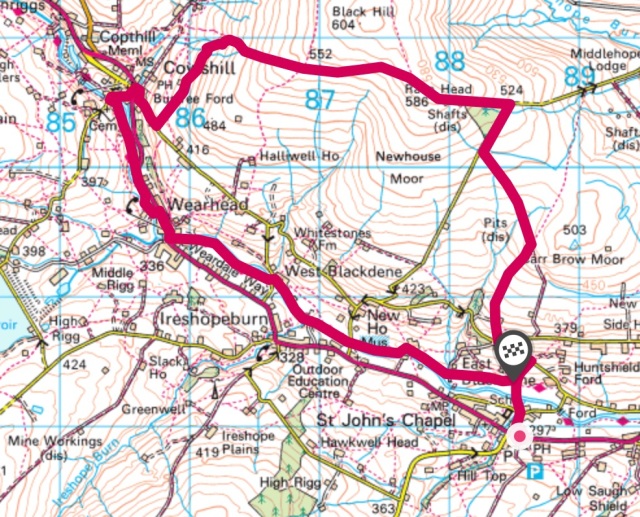
The map above gives a rough guide to the route – but we suggest you follow the directions above while studying your own map. The photos below give a taste of the views along the way.
*this article was co-written with my Taller Half*


Sadly I cannot follow your walks in person as I am far away in Australia. I am enjoying looking at your maps and where my ancestors lived. My ancestors were named Rutherford, Robson, Coatsworth, Walton, Gardiner, Dawson & others, all from Durham & all lead miners. My g.grandfather William Robson was a champion wresller & won a champions belt plus a purse which probably paid for their passage to Australia. Married to Margaret Rutherford in 1861 they came to Victoria where sadly William was killed in a mine collapse just 4 years later. Margaret then married George Gardiner, also from Durham. Census records give a good picture of where they were living at the time of the census & now your maps further show me just where those hamlets were . A wonderful website. My last visit o/s was 2013 but mostly in Scotland. Would love another trip, but now I have reached 80y I cannot see that happening. Now my travels are through Google. Thank you for a great site.
Glenda Smith (nee McGregor) of NSW Australia.
Hi Glenda. Thanks for your lovely comments. I’m glad you have found the maps helpful. Enjoy your google travels!
I am writing a book on my Durham family, I do hope you wont mind if I use your maps to show my family just where our ancestors came from. Of course I shall show you as my source. Do hope that will be okay with you.
Hi Glenda
You’ll be much better off using maps direct from the Ordnance Survey, who own the rights to the maps, and you’ll be able to explore the area better, and your maps won’t have red lines scribbled all over them. By all means share my blog with your family so they can see the route and photos direct from here.
Link to ordnance survey: https://osmaps.ordnancesurvey.co.uk
Thanks so much for your recommendation to use the Ordinance Survey maps. I have checked them out and now have a great picture of Durham, from around Stanhope to Wearhead & all those interesting towns & hamlets along the river Wear. Having spent a lot of time looking at Census records from 1841 I was able to find, on the OS maps many of the locations my ancestors lived at. I assume the many Quarry sites were the old Lead Mines, assume no longer being mined. Although the census records referred to eg Stanhope Forest Quarter St.Johns, I couldn’t find anything oin th OS maps that showed Forest Quarter. Do you happen to know what this means. Being a person who is out & about a lot, you may have an answer for me. I am aware that many/most of the men, & their sons were Lead ore miners and permanently rented their houses from the larger property owners. Seems the census takers just identified the areas a little differently with each census, but it was all the same place.
When in Scotland in 2013 we had a lot of farm stay accomodation and it was great to walk along the roads, unfortunately many of the walking trails were evident but were closed. I would have loved to have walked some of them. My garden help here, an Englishman, tells me that the farmers have a right to close the walking trails if they haven’t been used for twelve months & for that reason there was a man who made a point of walking trails every weekend, just to keep the trails open.
We don’t have walking trails like that here, but I do have family who spend a lot of time in the Blue Mountains (about 2 hours drive from Sydney). I have 5 children. #3 Andrew is a marathon runner, at age 50 he has retired from his work as an accountant in order to do something worthwhile with his life, like becoming a personal trainer. He has been organising groups to do runs each weekend. I don’t see much of him, he is too busy running somewhere with wife & friends. #4 Janelle & husband now spend every second weekend on a bush walk somewhere, often the Blue mountains, a second marriage for both gives them free time when kids are at other homes. #2 Trevor is a keen cyclist & does lots of high pressure rides. #1 Annette has 2 daughters who are very keen at sports & now we are entering the cooler months, winter sports have just begun. #5 (with son) is studying hard to become a qualified Naturapath, almost there. A lot of Australians are couch-potatoes, but not my family. I envy my kids so much, they have so much going for them and are living life to the full.
I would love another visit to the UK to walk some of your wonderful walks, which I really think are easier than bush walks here.
Many thanks, Glenda